Josef “Jeff” Sipek

Flight Planning My Cruise Power

When I was working on my private pilot certificate, there was one thing that was never satisfactorily explained to me: how to select the “right” line of the cruise performance table in the POH. Now that I’m a few years older and wiser, I thought I’d write up an explanation for those who, like me six years ago, aren’t getting a good enough answer from their CFIs.

I did my training in a Cessna 172SP, and so the table was relatively simple:

Reading it is trivial. Pick your cruise altitude, then pick the RPM that the instructor told you to use for cruising (e.g., 2200). Now, read across to figure out what your true airspeed and fuel flow will be. That is all there is to it.

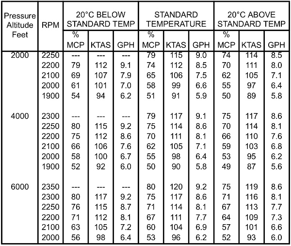
When I got checked out in the club’s 182T, things got more confusing. The table itself got split across multiple pages of the POH because of the addition of a new variable: manifold pressure (MP).

The table works much the same way as before. First, select the table based on which altitude you’ll be cruising at, then pick the RPM and manifold pressure, and read across the true airspeed and fuel flow.

On the surface (bad pun intended), this seems like a reasonable explanation. But if you look closely, there are multiple combinations of RPM and MP which give you the same performance. For example, in the above table both 2200/21” and 2400/20” give more or less the same performance. When I asked how to choose between them, all I got was a reminder to “keep the MP at or below the RPM.” It was thoroughly unsatisfying. So, I stuck with something simple like 2300/23”.

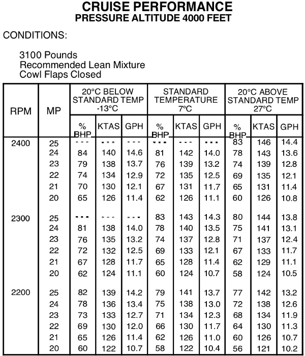
Fast forward to today. I fly a fixed gear Cessna Cardinal (177B). Its manual contains a table much like the one above for a 182. Here is a sample for 4000’:

As before, I started with something simple like 2300/23”, but eventually I had a moment of clarity. When flying the 172 and 182, I paid for Wikipedia article: Hobbs time. In other words, it was in my best interest to cruise as fast as possible without much regard for which exact RPM/MP combination I used (all within club and manufacturer limitations, of course).

My bill for the Cardinal is different—it is based on Wikipedia article: tach time. This means that the lower the RPM, the slower I’m spending money. So, like any other optimization problem, I want to find the right spot where my bill, my cruise speed, and my fuel flow (and therefore endurance) are all acceptable.

If the tach timer is calibrated to run at full speed at 2700 RPM, running the engine at only 2300 equates to 85% while using 2400 equates to 88.9%.

So, say I’m flying for two hours. If I use 2400 RPM, I’ll be paying 1.78 hours. On the other hand, if I use 2300 RPM at the same power output, I’ll be paying for 1.70 hours. Not a big difference, but after 24 hours at 2300 instead of 2400, I would have saved a full hour of tach time.

I don’t yet have enough data to verify these figures, but collecting it is on my todo list.

While composing this post, I happened to find an article by Mike Busch about why lower RPM is better. He makes a number of compeling points—reduced noise, better propeller efficiency, and fewer revolutions the engine has to make (which should improve the engine’s lifetime and therefore the overall cost). I have to admit that Mike’s points seems more compeling than the small savings I’ve calculated above.

2020-05-06

OpenMCT — While I’m not a fan of web-based UIs, this is a rather neat “dashboard” framework by NASA.

Wideband spectrum received in JO32KF — Over 5 years of HF spectrum waterfall in Enschede, NL.

10 Most(ly dead) Influential Programming Languages

Wikipedia article: PACELC theorem — An extension of the Wikipedia article: CAP theorem.

Learn Rust the Dangerous Way — Finally a Rust tutorial that speaks to people comfortable in C.

Interferometry and Synthesis in Radio Astronomy — An open access book.

Aviation Formulary — Great circle math applied to various aviation problems for those too lazy to derive the formulas themselves.

Papírová platidla Československa 1918-1993, České republiky a Slovenské republiky 1993-2016 — Complete list of all bank notes used in Czechoslovakia, Czech Republic, and Slovak Republic.

NOAA GOES Image ViewerWikipedia article: GOES weather satellite imagery.

IFR Alternate Minimums

As some of you already know, I’ve been working on my instrument rating over the past 5–6 months. As part of it, I had to figure out and understand the regulations governing when an alternate airport is needed and the required weather at the destination and alternate airports.

The first part is answered by 91.169(a) and 91.169(b). To give you taste of the regulations, here is (b):

(b) Paragraph (a)(2) of this section does not apply if:

(1) Part 97 of this chapter prescribes a standard instrument approach procedure to, or a special instrument approach procedure has been issued by the Administrator to the operator for, the first airport of intended landing; and

(2) Appropriate weather reports or weather forecasts, or a combination of them, indicate the following:

(i) For aircraft other than helicopters. For at least 1 hour before and for 1 hour after the estimated time of arrival, the ceiling will be at least 2,000 feet above the airport elevation and the visibility will be at least 3 statute miles.

(ii) For helicopters. At the estimated time of arrival and for 1 hour after the estimated time of arrival, the ceiling will be at least 1,000 feet above the airport elevation, or at least 400 feet above the lowest applicable approach minima, whichever is higher, and the visibility will be at least 2 statute miles.

Clear as mud, isn’t it?

The second question (the required weather at the destination and alternate airports) is answered by 91.169(c). Don’t worry, I won’t quote it here.

Since the text of the regulation is not easy to read, I decided that the best way to understand it is to make a flowchart. As I fly airplanes, I’ve ignored any part of the regulations that is about aircraft other than airplanes.

The result:

Clearer? I certainly think so!

The one big thing to keep in mind about this flowchart is that not every approach can be used during planning. This is a semi-large topic of its own.

In short, any approach that you aren’t authorized for, the plane isn’t equipped for, or that has a NOTAM saying that it isn’t available, effectively doesn’t exist. As far as GPS approaches are concerned, if you have a TSO 129 or 196 GPS, then you have another restriction—you cannot plan on using GPS approaches at both your destination and your alternate.

I found it useful to write this down and in the process truly understand the rules. Hopefully, you’ve found this useful as well. Needless to say, you should not rely on this flowchart without verifying that it is correct. Regulations sometimes change, and people sometimes make mistakes when making flowcharts to visualize said regulations. (If you find a problem, let me know!)

One final thought: just because the regulations don’t require an alternate airport doesn’t mean that you shouldn’t have one anyway. Weather often seems to have a mind of its own and a propensity to prove forecasters wrong.

My Logbooks

Recently a friend asked me about what I use for my pilot logbook. This made me realize that my logging is complicated and that I should probably make a blahg entry about it.

All in all, I have three logbooks to keep track of my flying.

Good ol’ paper logbook

This is the “official” one. In other words, if the FAA wants to see my logbook, that’s what I’ll show them. There’s not much more to say about it.

ForeFlight

This is my casual logbook. A while back I entered everything in, including more accurate counts (full stop vs. touch+go) and better divided up time counts (PIC vs. solo). I use this logbook to answer questions like “How much time do I have?” and “Am I current?”. It is also useful when chatting with people and I want to dig up an entry.

I also use it to keep track of Wikipedia article: Hobbs vs. Wikipedia article: tach time since I pay based on tach time.

A Repository

This is my custom analysis and archive logbook. In this Mercurial repository, I keep a giant JSON file with every entry with even more detail than what’s in ForeFlight.

Alongside it, I also keep a list of latitude/longitude/altitude information for each airport I’ve been to.

From these two files, I can generate various plots. For example, here is one:

Airports as of 2018-07-30

This is a plot of all the airports I’ve ever landed at—color coded based on the year of my first landing there.

This repository also serves as a backup of my paper logbook (in case my physical logbook burns up, gets water damaged, etc.) and an archive of other flying related data. I accomplish this by keeping scans of the paper logbook, copies of any GPS tracklogs I’ve recorded, and so on in a couple of subdirectories.

Post-flight

At the end of each flight, I add an entry to my ForeFlight logbook. Usually, I have ForeFlight recording a tracklog, so a large part of the entry is auto-generated. The bits of info that I add manually are:

  • tach time (useful for billing)
  • time out/off/on/in (I’m trying to figure out how much time I “waste” on the ground to improve my planning accuracy)
  • landing counts
  • any remarks I wouldn’t remember later

Then, when I’m home and have time (this can be later that day, or 3 days later), I pull up the ForeFlight entry, improve/edit the remarks, double check that all the counts make sense (if needed I pull up the tracklog to recount the number of landings, etc.), and then write an entry into my paper logbook.

If I filled up a page of the paper logbook, I scan the two pages and drop them into the repository.

Depending on how I feel, I may update the repository logbook JSON file then and there or at some point later (in the past I’ve even waited for a month due to laziness). Usually, visiting a new airport is motivating enough.

2018-06-05

Smart Clock: A New Time — Using three inexpensive wrist watches to achieve 1 second accuracy over an extended period of time.

Repairing the card reader for a 1960s mainframe: cams, relays and a clutch

The 555 Timer IC an Interview with Hans Camenzind—The Designer of the Most Successful Integrated Circuit Ever Developed

High-level Problems with Git and How to Fix Them — A Mercurial developer’s view of Git’s shortcomings.

Mailing lists vs Github

GDL 90 Data Interface Specification — Definition of the serial protocol used by Wikipedia article: UAT receivers to feed the received data to Wikipedia article: MFDs.

GDL 90 Extended SpecificationForeFlight’s extension to GDL 90.

OH-LCD

This post is part of a series named “Europe 2017” where I share photos from my adventures in Europe during the summer 2017.

When I attended the Kaivopuisto Air Show in early June last year, I learned about the existence of the Finnish Aviation Museum. It took me a month and a half, but eventually I found a free day to go check it out.

The museum itself is packed with all sorts of aircraft on static display. While they were interesting (and I certainly took plenty of photos of them), they aren’t what this post is about. This post is about Lokki—a retired Wikipedia article: DC-3 (registration OH-LCD) on display outside of the museum.

As luck would have it, the folks from the DC Association were there that day trying to see if they could start up Lokki’s engines—after 12 years of inactivity. After a lot of preparation, they managed to start them!

Without further ado, here are a few photos of Lokki (more photos can be found in the gallery).

Wikipedia article: Aero OY was the original name of Finnair:

One of the mechanics working on the left engine:

One of the people from the DC Association, seeing that I was obviously excited about the plane, asked me if I’d like to climb inside. I said yes, of course.

The inside was pretty bare-bones (which is to be expected of a static display that’s normally closed to public). I took a couple of photos inside, but most weren’t that interesting.

Throttle quadrant (note: most of the instrument panel was removed long ago):

It runs!

The livery is pretty simple—polished aluminum with dark blue lettering and a stripe:

I’m not really sure why they wanted to see if they could start the engines, but I’m happy that it worked out. Radial engines just have a unique roar to them.

Anyway, that’s it about Lokki. Hopefully I’ll get around to post processing the photos from the museum itself soon.

Kaivopuisto Air Show 2017

This post is part of a series named “Europe 2017” where I share photos from my adventures in Europe during the summer 2017.

In early June 2017, we attended an air show in Wikipedia article: Kaivopuisto. Unfortunately, we found out about it last minute, and so we missed the beginning which included a Finnair Airbus A350 flyby. Pity.

The show included a number of trainers and combat aircraft performing various maneuvers. Here are the highlights (for more photos visit the gallery).

Wikipedia article: Red Arrows:

A seagull joining in:

Wikipedia article: Finnish Coast Guard’s Wikipedia article: Turva nearby with Wikipedia article: Suomenlinna visible behind it:

Wikipedia article: Eurofighter Typhoon:

Wikipedia article: Saab 35 Draken:

Wikipedia article: Saab Gripen:

During one of the passes, I took a burst of images and then assembled them into a Southwest 737 “Airportrait”-style image.

Finnish Air Force Wikipedia article: F-18 Hornet:

A Finnish aerobatics team Wikipedia article: Midnight Hawks flying Wikipedia article: BAE Systems Hawk:

Even though this post has more photos than I typically share, there are many more in the gallery. So, if you are into airplanes, I suggest you peruse it.

2017-03-23

The million dollar engineering problem — Scaling infrastructure in the cloud is easy, so it’s easy to fall into the trap of scaling infrastructure instead of improving efficiency.

Some Notes on the “Who wrote Linux” Kerfuffle

The Ghosts of Internet Time

How a personal project became an exhibition of the most beautifully photographed and detailed bugs you ever saw — Amazing photos of various bugs.

Calculator for Field of View of a Camera and Lens

The Megaprocessor — A microprocessor built from discrete transistors.

Why Pascal is Not My Favorite Programming Language

EAA Video — An assortment of EAA produced videos related to just about anything aircraft related (from homebuilding to aerobatics to history).

The Unreasonable Effectiveness of Recurrent Neural Networks

Flying around Mount Monadnock

Last week I planned on doing a nice cross country flight from Wikipedia article: Fitchburg. Inspired by Garrett Fisher’s photos, I took my camera and the 70-200mm lens with me hoping to get a couple of nice photos of the landscapes in New Hampshire.

Sadly, after taking off from KFIT I found out that not only was there the stiff wind that was forecasted (that’s fine) but the air was sufficiently bumpy that it wouldn’t have been a fun flight. On top of that, the ADS-B unit was having problems acquiring a GPS signal. (Supposedly, the firmware sometimes gets into a funny state like this. The good news is that there is a firmware update available that should address this.) I contacted KASH tower to check if they could see my transponder—they did, so I didn’t have to worry about being totally invisible.

Since I was already off the ground, I decided to do some nearby sightseeing, landing practice, and playing with the Garmin GNS 430 GPS.

First, I headed northwest toward Wikipedia article: Mount Monadnock. While I have seen it in the distance several times before, I never got to see it up close, so this seemed like a worthwhile destination.

As I approached it, I ended up taking out my camera and getting a couple of photos of the hills and mountains in New Hampshire. It was interesting how the the view to the north (deeper into New Hampshire) is hilly, but the view more east (and certainly south) is flatter. (Both taken near Mount Monadnock.)

While the visibility was more than good enough for flying, it didn’t work out that well for photography. In all of the photos, the landscape far away ended up being heavily blue-tinted. No amount of playing around with white balance adjustment in Lightroom was able to correct it. (Either the background was too blue, or the foreground was too yellow/brown.) That’s why all of these photos are black and white.

I made a full turn around Monadnock, taking a number of shots but this one is my favorite:

Once done with Monadnock, I headed south to the Wikipedia article: Quabbin Reservoir in Massachusetts. This is a view toward the south from near its north end:

At this point I started heading to KORH to do some landing practice. Since I was plenty busy, there are no photos.

I’ve never been to this airport before and landing at new airports is always fun. The first interesting thing about it is that it is situated on a hill. While most airports around here are at 200-400 feet MSL, this one is at 1000 feet. The westerly wind favored runway 29 which meant I got to see a second interesting aspect of this airport. The beginning of runway 29 is on the edge of the hill. That by itself doesn’t sound very interesting, but consider that the runway is at 1000 feet while the bottom of the hill (a mere 0.9 km away) is at 500 feet MSL. That is approximately a 17% grade. So, as you approach the runway, at first it looks like you are way too high but the ground comes up significantly faster than normal.

I am still hoping to do my originally planned cross country flight at some point. Rest assured that I will blahg about it.

Plane-spotting in Manchester, NH

Last weekend I got to drive to Wikipedia article: Manchester, so I used the opportunity to kill some time near the airport by watching planes and taking photos (gallery).

The winds were coming from the south, so runway 17 was in use. I think those are the best plane spotting conditions at KMHT.

It is relatively easy to watch aircraft depart and fly directly overhead:

Unlike all my previous plane spotting, this time I tried something new—inspired by Mike Kelly’s Airportraits, I decided to try to make some composite images. Here is a Southwest Boeing 737 sporting one of the Wikipedia article: special liveries:

It was certainly an interesting experience.

At first I thought that I would be able to use the 7 frames/second that the D750 can do for the whole departure, but it turns out that the planes move far too slowly, so the camera buffer filled up way too soon and the frame rate became somewhat erratic. What mostly ended up working was switching to 3 frames/second and taking bursts. Next time, aiming for about 2 frames/second should give me enough images to work with.

Even though I used a tripod, I expected that I would have to align the images to remove the minor misalignment between images due to the vibration from the rather strong wind and my hand depressing the shutter. It turns out that the misalignment (of approximately 10 pixels) was minor enough that it did not change the final image.

Here’s an American Airlines commuter taking off from runway 17. (I repositioned to get a less head-on photo as well.)

For those curious, I post processed each of the images in Lightroom, exported them as TIFFs, and then used GIMP to do the layering and masking. Finally, I exported the final image and imported it back into Lightroom for safekeeping.

As a final treat, as I was packing up a US Army Gulfstream took off:

As far as I can tell, they use this one to transport VIPs. I wonder who was on board…

Powered by blahgd